The questions below will test your knowledge and help you determine if you are ready to take the FAA’s Instrument Rating Written Exam.
The altimeter would be the primary pitch instrument. The altimeter gives the most precise reading as to what the pitch is. If the altimeter is showing a rapid climb, the aircraft is in a very high nose up attitude. If the altimeter is showing a very slow rate of descent, the aircraft is slightly nose low. The attitude indicator shows what attitude the aircraft is in, but is imprecise on the amount of pitch. The airspeed indicator will change with pitch, such as showing an increase when nose down or decreasing when nose up, however it can be affected by other actions such as increasing or decreasing the throttle.
According to the instrument Procedures Handbook, “When ATC has not used the term nor imposed any climb restrictions, pilots should climb promptly on acknowledgment of the clearance. Climb at an optimum rate consistent with the operating characteristics of the aircraft to 1,000 feet below the assigned altitude, and then attempt to climb at a rate of between 500 and 1,500 fpm until the assigned altitude is reached. If at any time the pilot is unable to climb at a rate of at least 500 fpm, advise ATC. If it is necessary to level off at an intermediate altitude during climb, advise ATC.”

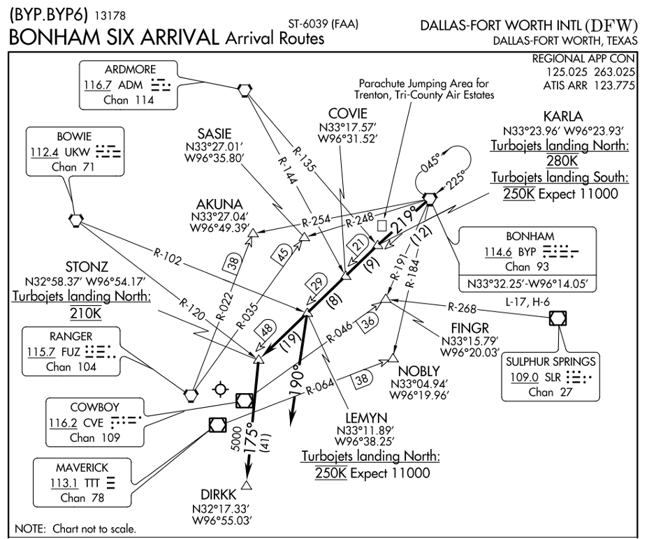
The arrival begins over the BYP VOR. The thinner lines are feeder routes that all lead to the BYP VOR. Since the thicker line comes from the BYP VOR, this is the actual arrival and approach routes. Along with the plan view of the approach, the heading on the top left corner will also state where the approach begins. The approach is the Bonham Six Arrival, and having BYP.BYP6 in the name shows that the arrival begins at BYP.

COP is an acronym for Change Over Point. The changeover point is where a pilot would switch frequencies for the VORs being used to navigate, and is denoted with this symbol: . There is also a number inside a D with an arrow pointing to a triangle, which is a waypoint. The number is the number of nautical miles from the VOR to the waypoint. In this case, at the changeover point, there are 30 miles from the VOR to the COP.
Radar services are terminated when center or approach instructs the pilot to contact tower. “[aircraft callsign] radar services terminated, contact _______ tower on [frequency]”
ATC (Air Traffic Control) may issue a STAR (Standard Terminal Arrival Route) to an aircraft when it is approaching an airport for landing. A STAR is a published route that helps to guide an aircraft from the en route phase of flight to the terminal phase of flight, where it will join the approach and land. ATC will issue a STAR to an aircraft to ensure the safe and efficient flow of air traffic and to help guide the aircraft to a safe landing at the destination airport, unless the pilot specifically asks for no STAR.
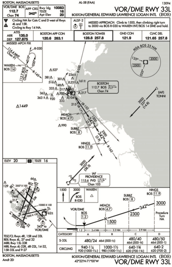
On the approach plate, in the bottom left corner is the airport sketch. Within that sketch, runway 33L is in the bottom right corner. Each of the runways has the distance and width labelled with an arrow. Following runway 33L, there is “10083 x 150” with an arrow pointing to 33L. This means that the landing distance available is 10,083 feet and the runway is 150 feet wide.
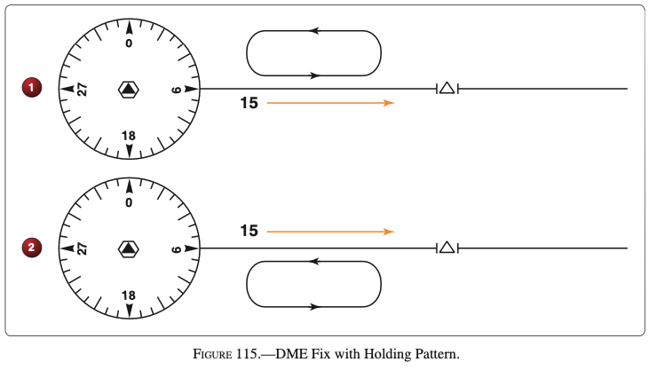
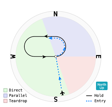
Unpublished holds can be very confusing. In this scenario, while on a heading of 350 and approaching the hold point, to hold on the 090 radial to the west of the fix, the proper holding procedure would be in number 1. Number 2 would have the aircraft facing the incorrect direction at the fix. Since holding west of the fix on the 090 radial, the aircraft would be approaching 15 DME from the west on the 090 radial. The Aeronautical Information Manual (AIM) section 5-3-8 recommends different entry procedures based on the location of the aircraft and the fix. In this circumstance, the aircraft is on a 350 heading, which falls within the sector for direct entries.
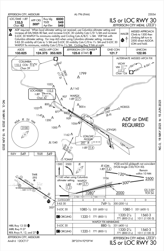
When on approach and the glideslope of the ILS fails, the pilot should transition to the localizer approach, which includes changing from a decision altitude (DA) to a minimum descent altitude (MDA). It is not necessary for the pilot to execute the missed approach immediately since the localizer is still functioning properly. Pilots should not switch approach types during the approach, such as from the ILS to GPS, because there may be different points and altitudes that could cause an aircraft to conflict with traffic or collide with terrain. If a pilot wishes to transition from one approach to another, the pilot should execute the missed approach and request a different approach from ATC.
An instrument-rated pilot, who has not logged any instrument time in 1 year or more, cannot serve as a pilot in command under IFR, unless the pilot has completed and passed an instrument proficiency check (IPC) administered by an authorized instructor or examiner. The Federal Aviation Administration (FAA) requires instrument-rated pilots to complete an IPC every 12 calendar months to maintain instrument currency.
During the IPC, the pilot is evaluated on various instrument flying tasks, including attitude instrument flying, navigation, and approaches. The evaluation ensures that the pilot is proficient and competent to fly under instrument flight rules (IFR) and make safe decisions in challenging weather conditions. Upon passing the IPC, the pilot’s instrument currency is renewed for an additional 12 calendar months.
It is essential for instrument-rated pilots to maintain their instrument proficiency and currency to ensure safe and effective IFR operations.
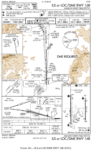
TDZE stands for Touch Down Zone Elevation. In the bottom right corner of the approach plate is the airport sketch. On the top right of the sketch is the TDZE, which indicates 363. This stands for 363 feet MSL.
An unstable cold air mass moving over a warm surface can result in significant weather conditions, including thunderstorms, heavy precipitation, and strong winds with good visibility. If a cold air mass is already unstable, heating it from below will further increase its instability. Unstable air leads to cumuliform clouds, turbulence, and good visibility.
On an IFR En Route Low Altitude Chart, limits of controlled airspace, MTRs and special use airspace are depicted. Class A airspace is not depicted on any chart.
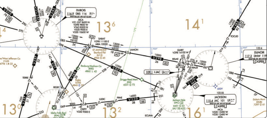
The Minimum En route Altitude (MEA) on V520 is 15,300. Eastbound IFR flights are conducted at odd numbered altitudes, and pilots cannot fly below the MEA, so the lowest an IFR aircraft could fly would be at 17,000 feet. Above 15,000 feet, the flight crew must use oxygen the entire time and the passengers must be provided supplemental oxygen.
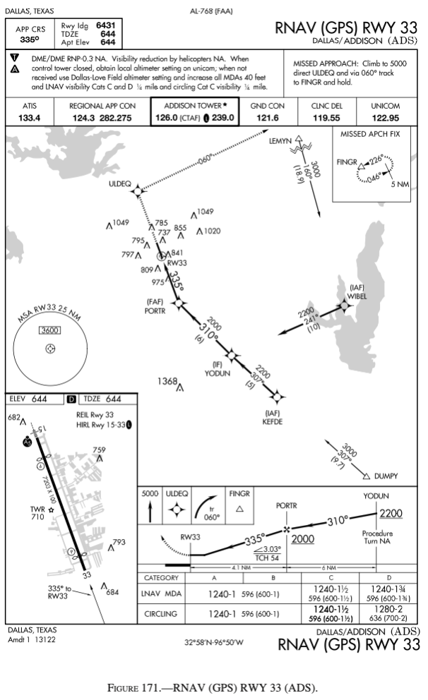
Below the profile view at the bottom of the chart are the minimums. The category is not specified, but of the answers, 1240-1 is an appropriate answer. This translates to 1,240 feet MSL for the minimum descent altitude and 1 statute mile of visibility. Remember, visibility is always in statute miles not nautical miles.
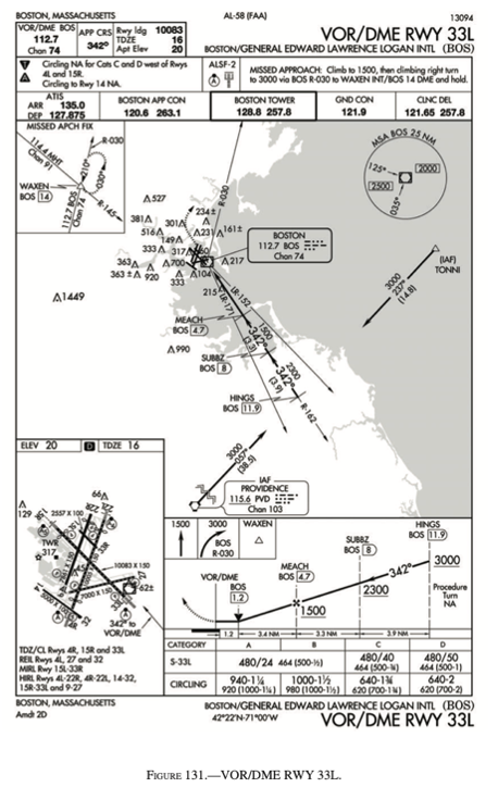
On the profile view of the approach, there is a thick black V approximately 1.2 miles from the BOS VOR. This is the visual descent point. The Aeronautical Information Manual (AIM) section 5-4-5 defines the VDP as “identified by the symbol (V), is a defined point on the final approach course of a nonprecision straight-in approach procedure from which a stabilized visual descent from the MDA to the runway touchdown point may be commenced. The pilot should not descend below the MDA prior to reaching the VDP.”
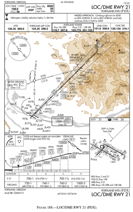
The MSA indicated on the top left of the plan view of the chart indicates that, with the BTG VOR as the reference, between headings of 300 and 120, the safe altitude is 6,200 feet within 25 NM, since that number is to the right of the two headings. This would make sense as well, since there is a significant amount of terrain along the approach.
According to the Federal Aviation Regulations (FARs), the minimum altitude prescribed for off airways IFR flights over mountainous terrain is 2,000 feet above the highest obstacle within a horizontal distance of 4 nautical miles of the course to be flown. However, this minimum altitude may be decreased to 1,000 feet above the highest obstacle if the course to be flown is more than 4 nautical miles from the nearest edge of the mountainous area. These rules are specified in FAR 91.177.
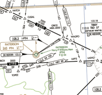
Low altitude IFR charts are used for navigation. When the localizer is depicted on a chart, it means that the localizer has additional functions as a navigational function.
An abrupt change from climb to straight-and-level flight can create the illusion of tumbling backwards or flipping over backward, known as the somatogravic illusion. This illusion is caused by a sudden forward movement of the otolith organs in the inner ear, which sense changes in linear acceleration and can be easily fooled by abrupt aircraft maneuvers. Pilots can mitigate this illusion by cross-checking their instruments and relying on visual references outside the aircraft.
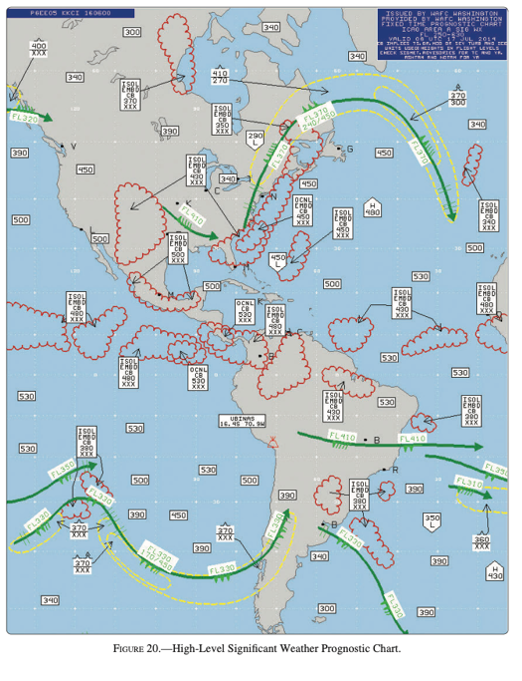
On the high level significant weather prognostic chart, over Mississippi, there is a green arrow showing the air currents are flowing in a southeast direction. On this green arrow, there is a flag and then four barbs. Just like with METARs, the flags and barbs equal the same. The flag is worth 50 knots, and four barbs at 10 knots each equals 90 knots.
When encountering icing conditions, pilots should take immediate action to exit the area of icing conditions. This may involve a change of altitude, a deviation from the planned route, or a diversion to an alternate destination. Pilots should also turn on all available anti-ice and de-ice systems on the aircraft and monitor their effectiveness. It is important to maintain communication with ATC and report the type and intensity of icing encountered, as well as the effectiveness of the anti-icing measures taken. Additionally, pilots should review and follow the aircraft’s icing procedures as outlined in the manufacturer’s information and the appropriate regulations.
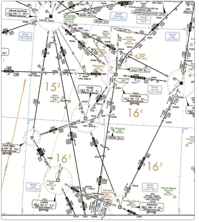
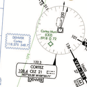
If communications are lost, locating the center radio frequencies is important in reestablishing communications. The blue zigzag lines contain the name of the center and the frequencies for that sector. In this instance, by the Cortez VOR, there is a box that contains Denver and frequencies of 118.575, and 348.7, so this correct frequency for Denver Center is 118.575
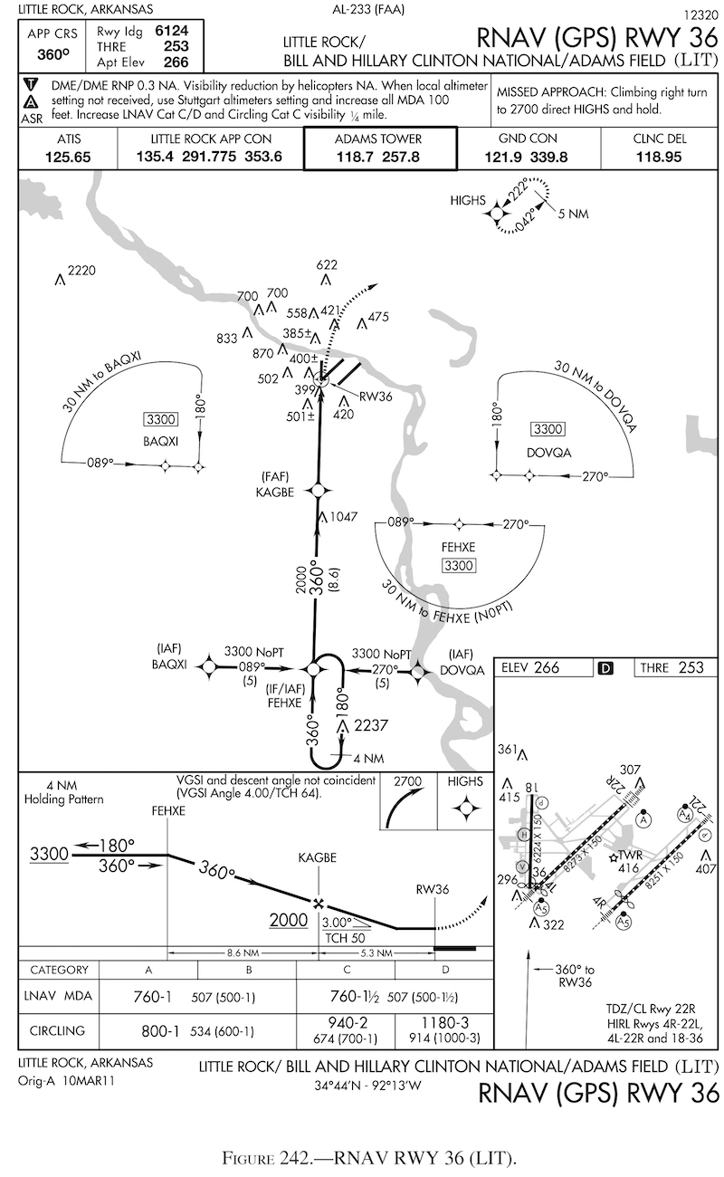
When flying the hold, this reversal begins four miles from FEHXE. So when flying the course reversal, the turn would begin 4 miles past the fix. The missed approach point is just that, the point that the missed approach is executed and has nothing to do with course reversal. This approach uses the GPS, so using DME to measure from a VOR that does not appear to be depicted on the approach plate would be inappropriate and cause excessive work for the pilot. Pilots should not transition between different approach types when on an approach.
VORs (VHF Omni-Directional Range) use VHF radio signals to determine an aircraft’s position relative to a ground station. When an aircraft is directly above the station, it is said to be in the station’s “cone of confusion.” At this point, the signals from the VOR station are being received by the aircraft’s VOR antenna from both the ground and the sky. This can lead to inaccurate readings or errors in the displayed radial. The greatest errors are likely to occur when the aircraft is at high altitudes directly over the VOR station, as the angle of incidence between the signals from the VOR and the aircraft’s receiver becomes very small. As a result, it is recommended that pilots fly at least 1,000 feet above the highest obstacle within a horizontal radius of 5 nautical miles of the VOR station to avoid this issue.
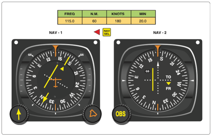
Nav 2 is showing a displacement of the needle over the second dot to the left. If the needle can deflect a maximum of 10 degrees, with 5 dots, that will mean each dot has a value of 2 degrees. If the needle is deflected two dots to the left, that will mean that the displacement is 4°.
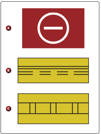
The top sign (A) indicates that aircraft are prohibited in the area.
The tailplane, also known as the horizontal stabilizer, is the most susceptible point for icing because it is located in an area of low-pressure airflow behind the wing. This low-pressure area causes moisture in the air to freeze onto the surface of the tailplane more easily than other areas of the aircraft. Additionally, the tailplane is typically made of a thin, flat surface, which provides a large area for ice to accumulate. If too much ice builds up on the tailplane, it can cause the aircraft to become unstable and difficult to control.
If, while in level flight, a pilot has to use an alternate source of static pressure vented inside the airplane, it will cause an increase in indicated altitude and an increase in airspeed. The altimeter will indicate a higher altitude due to the lower static pressure inside the cabin, while the airspeed indicator will show a higher airspeed because of the higher dynamic pressure outside the aircraft. Therefore, the pilot should compensate for these changes when using an alternate source of static pressure.
The “sterile cockpit” rule is a regulation that requires pilots to refrain from non-essential activities during critical phases of flight, such as takeoff and landing, and to focus solely on flying the aircraft. This rule is not just for airline pilots, but for all pilots as it helps to ensure maximum safety during these critical times of flight. By minimizing distractions, pilots can remain focused on their duties and maintain situational awareness, reducing the risk of accidents or incidents. The rule applies to all types of flying, from general aviation to commercial airline operations, and is an important aspect of maintaining safe and efficient operations.
Spatial disorientation can be prevented or overcome by relying on flight instruments and avoiding reliance on the sensory system, avoiding abrupt head movements, avoiding visual illusions, and maintaining spatial orientation through practice and training. Pilots should also be aware of the potential for spatial disorientation in different flight situations and take appropriate precautions.
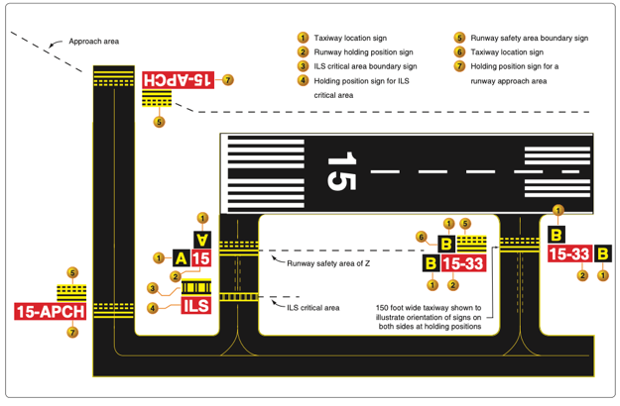
Holding signs will always have white numbers with a red background.
Stable air has a tendency to remain in place and resist upward vertical movement. It typically has cool temperatures, high atmospheric pressure, and high relative humidity. When stable air is forced upward, such as over a mountain range, it can lead to the formation of clouds, precipitation, and turbulence. In aviation, flying in stable air is generally considered more smooth and predictable, but it can also lead to reduced visibility and cloud ceilings.
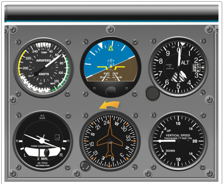
In this scenario, the airspeed indicator is showing a very low airspeed, the attitude indicator is indicating a turn to the right, the altimeter is indicating 4,000 feet, the turn coordinator is showing a slipping turn to the right, the directional gyro is indicating a turn from 250 to the right, and the vertical speed indicator is showing no climb or descent. From all available information, the instrument that has failed is unknown at this point. The attitude indicator shows the right wing low and left wing high, which indicates a right turn. The altimeter and VSI both do not show a climb or descent, and the turn coordinator and gyro both are indicating a turn to the right. The gyroscopic instruments, both vacuum and electronic, are showing that the aircraft is turning to the right. Since the pitot static system instruments are not showing a change and the airspeed is unusually low and below the green arc, which is the normal operating range, a pilot should be alarmed with airspeed this low. Even with the pitot static system failed, those instruments would show some sort of change if the aircraft was climbing or descending, albeit incorrect. This means the aircraft is in a level turn to the right, with the pitot static instruments failed.
If the pitot tube and drain hole become blocked, the airspeed indicator will act like an altimeter, showing the same airspeed regardless of the actual airspeed. This is because the air pressure inside the pitot tube, which measures the ram air pressure, is no longer changing and is equal to the static pressure. Without a difference between ram air pressure and static pressure, the airspeed indicator cannot accurately measure airspeed.
A certificated commercial pilot who carries passengers for hire at night or in excess of 50 NM is required to have at least an instrument rating.